Catastrophe Management Services
![]()
CatMgmt's website www.catmgmt.com was recently nominated for
Business Insurance's "Best of the Web" award.
Phone: 253.272.2092
Toll-Free: 1.888.272.2092
Fax: 253.272.4758
the M-factor
published by McKay/Moore Construction Cost Control Consultants (WBE/DBE)
Editor's Note:
In this issue, we are featuring a client with whom we worked for the first time just last year. Catastrophe Management Services (or CatMgmt, as the firm also refers to itself) provides a unique service, one that seems appropriate to highlight in our earthquake-prone area.
In the Pacific Northwest, residents have always been aware of this region's seismic vulnerability. [In McKay/Moore's Winter 1999 newsletter, we focused on Seismic Issues. If you missed that issue or would like to re-read it, follow the navbar on the left of our web page down to Newsletter Archives, 1997-2000, and click on Winter 1999 Feature: Seismic Upgrades & Retrofits.]
Since February 2001's Nisqually quake, there has been a great deal of press about the earthquake damage we sustained and disaster (specifically earthquake) preparedness. This issue's featured client manages disaster recovery. Whether Catastrophe Management Service's clients are coping with earthquake, fire, flood, or oil spills, drawing from a nationwide network of specialists, the firm matches experts to needs to ensure that its clients have the proper resources and tools to help recover quickly from a loss.
McKay/Moore's recent association with CatMgmt was in providing them with a cost estimate addressing building code issues involved in a fire damage repair claim.
This issue's Featured Client:
Catastrophe Management Services
![]()
CatMgmt's website www.catmgmt.com was recently nominated for
Business Insurance's "Best of the Web" award.
Phone: 253.272.2092
Toll-Free: 1.888.272.2092
Fax: 253.272.4758
Catastrophe Management Services, Inc., of Tacoma, Washington, is a unique organization whose services range across three distinct but interlocking areas: catastrophe management, dispute management, and risk management.
After a loss, the primary goal of any business is to restore operations as quickly, completely, and cost-effectively as possible, to get the full benefit of any insurance coverage it is entitled to, and to be in complete control of all critical business decisions.
CatMgmt offers independent, objective advice and analysis. They have served as independent appraisers for both insurance carriers and policyholders, providing arbitration and litigation support; expert testimony on damages, insurance policies and procedures; insurance coverage reviews; claim documentation advice and assistance.
On every loss, CatMgmt deals with issues that never arise during ordinary daily operations and which the client's insurance coverage may not address. CatMgmt is often asked to review clients' facilities, operations and coverage with their agent or broker to make certain that the right experts and the right coverage, if ever needed, are in place. They offer objective advice, backed by their post-loss experiences, with which to measure what the client has against realistic needs.
After a loss, everyone, from senior management to the insurance adjuster, in interested in finding an experienced, knowledgeable professional who has a clear understanding of the contractual issues and can chart a path to determine the damage, document the costs, and expedite the recovery. It is CatMgmt's mission to fill that need. Their Mission Statement is to provide their clients with the best possible tools, resources and assistance with which to measure, manage, and recover from loss. Their role is, in their own words, "to compliment your expertise with our own special skills and experiences. We'll work with what you have — and find what you need. Insured or uninsured, covered or not, we'll offer objective advice and analysis and do as much —or as little — as you need." They:
Catastrophe Management Services' single goal is to assist clients to recover from property losses. From Barrow, Alaska to Key West, Florida, they have helped their clients with everything from restoring critical records to rebuilding entire plants.
After a Bend, Oregon, resort facility was destroyed by fire, CatMgmt assembled a team of reconstruction experts that both underbid and outperformed the local competition. Careful management of the construction timetable saved more than $92,000 in direct costs on the $1.35 million reconstruction - while completing the project 6 months ahead of schedule - saving the owners over $80,000 in lost revenues.
When fire destroyed the processing facilities of a commodities exporter in Boardman, Oregon, their team of reconstruction experts reduced the reconstruction timetable from 17 to 9 weeks, saving the owners more than $600,000.
In Portland, Oregon, when floods repeatedly inundated a major wood products plant for almost 30 days, insurance company experts estimated $450,000 in building and equipment damage. CatMgmt's loss and damage estimate was more than $2.0 million, a figure with which those same experts ultimately agreed.
In December 2000, McKay/Moore Consultants provided CatMgmt with a cost estimate, addressing building code* issues that applied to the fire damage repair of the Asher Apartments in Aberdeen, Washington, and the construction of the Emerald Court Apartments in Puyallup, Washington, a 22-unit townhouse complex built 1999-2000. Our work was submitted to an insurance company as documentation for some costing issues.
*The current Washington State Code has expanded from a building code to cover energy codes, indoor air quality codes, the handicap access code, and numerous others.
It has very strict requirements for handicap access units. This code is very specific in parking space size, location and marking, in door sizes, hardware and swing, in plumbing fixtures, light switch location and many other features.
Our estimate covered the cost to upgrade materials that do not meet the current codes or are new in recent years. In the case of materials like windows, plumbing fixtures, doors, or similar items the cost to upgrade to current codes were used. In the case of items that are new to recent codes, the cost of installing the new items was included, such as the seismic bracing required by the new codes. Other items were new requirements for old materials; for example, draft stops in the attic between units, the gypsum sheathing on the exterior to meet the requirement on multi-unit apartments for one-hour construction, and increased insulation to meet the energy code.
 David J. Gadbois, Principal of Catastrophe Management Services, has extensive experience in insurance claims, including many years with the Home Office Property Claims unit of a major commercial insurer. He has trained and supervised adjusters in all aspects of property and business interruption loss. His extensive 'hands-on' field experience includes earthquake, fire, collapse, hurricane and construction losses.
Mr. Gadbois brings a business owner's perspective to the art of loss management: "You might be able to make up for lost time. Lost customers, a missed opportunity, once gone, are almost impossible to recover. The key to managing a catastrophe – or the disputes that follow – is early intervention, matching the right experts to the problem, identifying issues before they become obstacles, and never losing sight of the goal – getting back to the business of serving customers. Few adjusters have any understanding of the needs of a business owner. Adjusters are trained in insurance, not in business. Most have no idea what it is like to own, run or manage a business." (As an aside, Mr. Gadbois remarks, "Both a medical transcriptionist and a court reporter would know/be familiar with medical terminology - but I wouldn't expect either of them to fill in for a physician or pharmacist.") "Managers find themselves forced to choose between staying focused on critical issues or to divert scarce resources to respond to the insurer's requests for more documentation and information."
A trained mediator as well as experienced negotiator, Mr. Gadbois has served businesses, insurers, public entities, bankruptcy trustees and their Counsel as a consultant, impartial appraiser, arbitrator, and trial expert since 1978. CatMgmt was formed in 1996.
Note: If you are a client of McKay/Moore Consultants and would like to see your firm profiled in an upcoming issue of our paper and online newsletter, please contact the Editor at mckaymoore@strabo.com.
Web links – NW Hazards:
Since our Winter 1999 issue, we have discovered a number of updated links to seismic information on the Web. A few of them are listed below and can also be found on our Design and Construction Resources LINKS page. (Again, this can be found on the navbar at www.mckaymoore.com.)
Nisqually Earthquake - Strong Motion Data / Seattle Seismic Hazard Mapping Task at http://groundmotion.cr.usgs.gov/nisqually/data.html shows data from the urban seismic array in Seattle deployed and operated by the Geologic Hazards Team of the USGS. This information can be easily downloaded from the site into an Excel spreadsheet. Immediately following the magnitude 5.3 Duvall earthquake of 3 May 1996, the U. S. Geological Survey installed an array of 15 seismographs in urban Seattle to record ground motion caused by Duvall aftershocks and other earthquakes that occur nearby. They are using the earthquake records to measure how much the ground motion is amplified at sites located on sediments and fill compared to sites located on hard rock. The goal of the site response study is to define the earthquake shaking that can be expected to affect the city on a neighborhood-by-neighborhood basis.
FEMA http://www.fema.gov/diz01/d1361.htm has an Earthquake Recovery News Summary. As of 30 July 2001, disaster assistance has topped $129.7 Million.
WSDOT's Research Office has an interesting web page at http://www.wsdot.wa.gov/ppsc/research/rpage.htm where you can click on various links, such as Bridges & Structures, read Recent Reports, Seismic Studies associated with King Dome Implosion, and a link to a site listing Recent Earthquakes in NW (updated after every earthquake or once a day).
See the clickable picture of the Earthquake Rose (shown here) on the upper left corner of the WSDOT page referenced above.

National Earthquake Information Center: World Data Center for Seismology, Denver http://wwwneic.cr.usgs.gov/current_seismicity.html
Landslides issue paper: http://www.odf.state.or.us/FP/FPAC/SectionC.htm
Seattle's Emergency Management website at http://www.ci.seattle.wa.us/emergency_mgt/iconPages/index.htm has an interesting and fairly comprehensive history of destructive events that have occurred in and around the Pacific Northwest. The list ranges from full-scale disasters to what they refer to as "wake up calls", like earthquakes in the mid-1990's.
Click on Disaster History under Hazards to view the list. The history is not only very interesting but also reminds us that disasters such as are shown here can and do happen in our area. Here are some excerpts:
Jan. 1893 45.5 inches of snow fell in less than two weeks. [The average snowfall recorded at Sea-Tac Airport from 7/23/1931 to 12/31/2000 is 11.7 inches. In urban Seattle, the average is just under 5 inches. ]
Water shortages are listed frequently in our history, for example:
1928/29 There was a long drought that lasted nearly a year. Rain was 20% of normal. This had been the longest recorded drought in Washington to date.
1976/77 Precipitation was 57% of normal in Seattle. Hydroelectric power generation dropped 47%. City Light was forced to purchase emergency power at highly inflated prices, leading to surcharges on electric bills.
[The five-month period from October 2000 through February 2001 was the second driest on record for Seattle --- only 13.54 inches of precipitation fell during this time period; the record low precipitation for this time period is 8.01 inches set in 1976-77. The normal precipitation total for this five-month period is 24.34 inches.]
Our area is, of course, very seismically active. The Puget Sound basin averages a magnitude 6 or so earthquake every 35 to 40 years:
Dec. 1872 A magnitude 7.4 shallow quake shook the North Cascades, triggering a huge landslide that temporarily blocked the Columbia River.
Wind is one of the most frequently mentioned hazardous events:
Sept. 1962 The area's first confirmed tornado touched down west of Sand Point, severely damaging several homes.
Apr. 1972 Vancouver, WA. A tornado developed as part of a regional windstorm near Portland, Oregon. It moved across the Columbia River and killed six people, injuring 300 more and causing $6 million in damage.
10/12/1962 In this Columbus Day Storm, winds of 85 m.p.h. (equal to hurricane speed) hit the area. Damage was widespread. Forty-six people died, 53,000 houses were damaged, and power went out in many areas of the state.
Besides water shortages, storms, and earthquakes, many instances of landslides, terrorism and civil disorder, and flooding (not to speak of 1980 volcanic activity and the 1889 fire that consumed 60 acres in downtown Seattle) are delineated in our local history. It is clear that disaster preparation and recovery are issues that have and will continue to impact us.
Landslides – Human Impact:
Over the years there have been scores of Puget Sound landslides, including the 1996 Perkins Lane slides http://www.ecy.wa.gov/programs/sea/landslides/show/magnolia.html on Magnolia Bluff in Seattle. McKay/Moore Consultants became involved in estimating losses to homes damaged in the Perkins Lane slides. The legal, financial, and personal ramifications to owners have continued for years.
Some of the natural causes of landslides are water erosion of the soil, gravity, unstable soil layering, and wind erosion/ tree fatality. Human influences are often more devastating: construction, weight of houses, excavating hills, changing natural water movement and ground permeability through paving etc., and clearing vegetation and root systems. A number of studies, including by students at the soils lab at the University of Washington, have determined that at Perkins Lane the dominant cause of sliding was the unstable soil layering of clay1 on till2 made more vulnerable by excavation into the hills done by humans.
1 clay: very fine sediment that settles in still water – The Puget Sound area was underwater as recently as ± ten thousand years ago, allowing a clay layer to develop in our region.
2 till: poorly sorted chunks of sediment dropped as a glacier recedes – The greatest part of the entire Puget Sound region consists of silt, clay, sand, and gravel deposited by the extensive continental glaciers of Quaternary age. 18,000 years ago, the Puget Sound basin was buried under ice a mile thick at Bellingham, 3,000 feet deep at Seattle and 1,500 feet at Olympia.
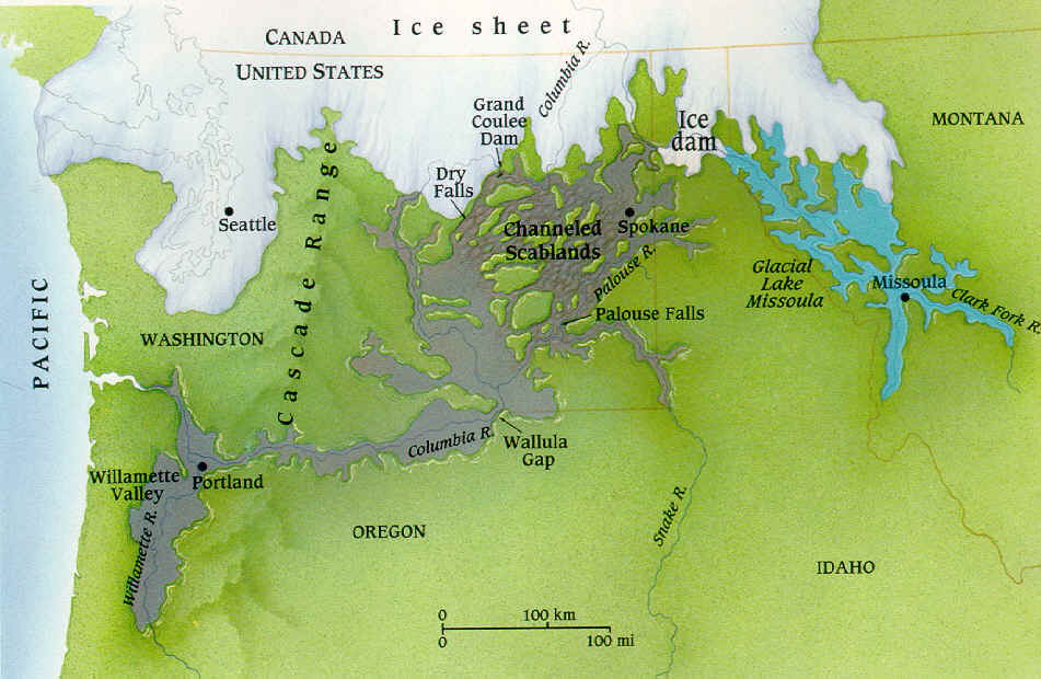
At http://www.forestry.umt.edu/ntsg/personnel/mattj/glm/home.htm is a discussion of the Missoula Flood and a map showing floodwaters from Glacial Lake Missoula, which moved through eastern Washington on a 430-mile journey to the Pacific Ocean ± 10,000 years ago.
In an article from Washington Geology, vol. 25, no. 1, March 1997, "Puget Sound Bluffs: The Where, Why, and When of Landslides Following the Holiday 1996/97 Storms", http://www.wa.gov/dnr/htdocs/ger/pugetls.htm, the authors describe the typical undisturbed stratigraphy in the central Puget Sound area consisting (from the top down) of a thin soil layer overlying relatively impermeable till (what gardeners know all too well as "hard pan"), permeable sands, and/or nearly impermeable clays and ancient lakebed silts.
There is much "old news" in information on these issues published in the last few years. In researching this article, I ran across a study entitled LANDSLIDES IN SEATTLE prepared by Donald W. Tubbs in cooperation with the U.S. Geological Survey in a quarter century ago. Attempting to identify the reasons for landslides in the Seattle area, the Division of Geology and Earth Resources, in cooperation with the U.S. Geological Survey, began studying the landslides in the spring of 1972. Mr. Tubbs, a graduate student at the University of Washington who was interested in landslides, was selected to do the job. He made a thorough search of city records and interviewed many people in the Seattle area in order to arrive at damage estimates. He also examined many of the slides in an attempt to identify the geologic, climatic, and human factors that were responsible for the slides. He concluded, "There is probably no such thing as a single cause of a landslide. A number of conditions usually interact to make a rock or soil mass susceptible to sliding, although commonly a single factor can be identified as finally triggering the movement. In the Seattle area, geologic events resulted in a particular set of deposits and landforms. It was the interaction between these geologic conditions and certain climatic conditions, and ...human activities that produced the landslides of early 1972... Many of the landslides involved certain human influences. Modification of building codes and grading ordinances to regulate such activities in particularly hazardous areas should be considered as a means of minimizing future landslide damage." See http://www.tubbs.com/ic52/ic52.htm.
Until we humans become smarter about the way we interact with our land, we will continue to suffer unnecessary and devastating losses. An interesting discussion on this topic and conclusions regarding ways to reduce landslide occurrence (not the least of which is educating people who live in those critical areas not to top and cut down trees which are crucial elements for preventing soil erosion) is presented at UW Soils Lab site: http://depts.washington.edu/qrc/research/pnw/soils_land_use.htm.
A cooperative, interdisciplinary, interdepartmental UW study of Soils and Land Use in the Puget Sound Basin, including an overview of current (1994) land use issues, can be found at http://soilslab.cfr.washington.edu/.
Finally, an excellent resource on Seattle landslides is http://students.washington.edu/gwyneth/sci115landslides.html. At the bottom of this web page are listed over 20 websites, technical and non-technical, including some with information about effects of the 2/28/01 Nisqually earthquake.
